In the past (eg. 1950s), individuals with physics and mathematics degrees were trained to become geophysicists by companies and government institutions. Modern geoscience includes two major branches; geology and geophysics. Hundreds of universities across North America offer undergraduate BSc programs in geophysics. Geophysics can be defined as the mathematical approach to geology. It integrates both physics and natural geology into one subject matter. One of the most fundamental methods of geophysical data gathering is seismic survey.
Scan of Subsurface
When medical doctors want to peek into the inner working of your body they might use x-rays, MRIs or sonograms. The objective of a seismic survey (“geophysical survey”) is to obtain subsurface data. It is a scan of what lies beneath your feet up to hundreds of meters to kilometers. However, the raw data obtained through seismic surveys are almost always incoherent. This is where skilled geophysicists and their mathematical algorithms become very important.
How do we obtain it?
X-rays and GPR (Ground Penetrating Radar) cannot produce strong enough “signals” to penetrate hundreds of meters of earth. GPR is often used in archaeological research because most burial sites and ruins are buried relatively close to the surface. To understand geological settings, we need a better method. We need signals that can penetrate several kilometers into the subsurface and travel back to receivers that gather the data. This is where seismic surveys are useful. They are widely used in petroleum industry and most of the advancement in seismic survey research has been funded by companies like Imperial Oil, Royal Dutch Shell, etc.
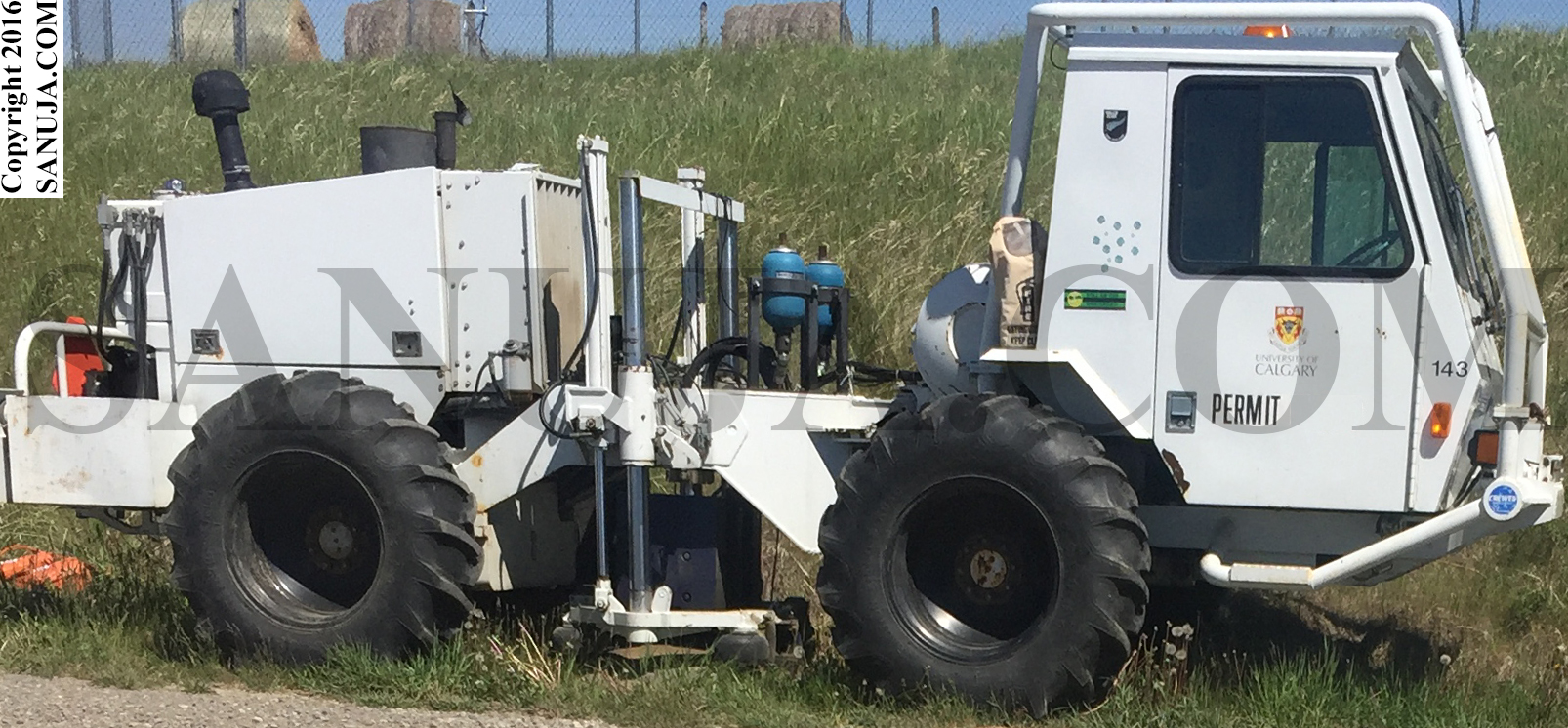
Seismic surveys use sound waves (vibration waves) or pluses. These waves are artificially produced by either using explosives such as dynamite or TNT or through a seismic vibrators (vibrator trucks, Figure 1). In the early days, geophysicists used explosives exclusively but the technology has advanced to the point where small trucks with large “hammers” called thumpers that can produce sound waves. A major advantage of using these vibrators is that waves with known amplitude and frequency can be produced. The amplitude and frequency of the initial wave is important when analyzing the data. I will not go into detail on how it is done because it is a very complex and highly evolving subject matter. But you should be aware that it is useful to know the characteristics of the initial wave.
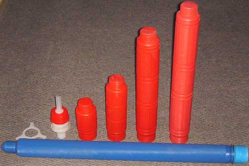
The explosive method involves drilling a well (hole) in the ground and inserting tubes (charge containers) filled with explosives and detonating them. This method is still useful where you need to obtain data in very complex regions where the vibrators cannot produce enough energy to penetrate subsurface structures. Examples of charge containers are shown in the following image (Figure 2). The long blue tube is an industry standard 2 kg (two kilogram) charge container. A hole up to 80 m depth can be drilled and charges can be inserted using this device.
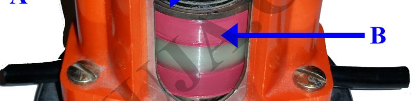
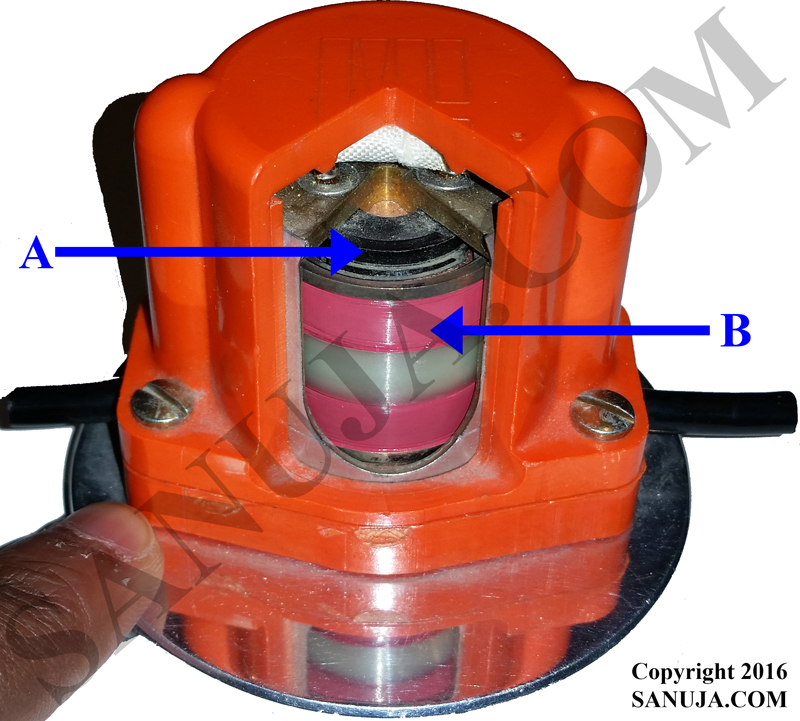
The waves generated on the surface travel through different layers of rocks and sediments. The waves interact with geological materials and “bounce” back to the surface. Once it is on the surface, it is picked up by a device called a “geophone”. Just as a microphone measures vibrations in the air, a geophone measures vibrations in the ground and converts them into electrical pluses. The electrical pluses (signals) are generated by movement of a coil in a magnetic field in the geophone (Figure 3). These pluses can be recorded and processed into useful data. Two types of commonly used geophones; flat base geophones (Figure 3) and spike geophones. The spike type is inserted to the ground whereas the flat base geophone sits on the surface.
Geophones can also be used for recording natural earthquakes and tremors. Data acquired though geophones in a seismically active area are used for early warning systems. Regardless of whether the project is monitoring an unexpected earthquake or working on a petroleum exploration project, several geophones must be used to locate the earthquake origin (tens of geophones) or to understand the subsurface structures of a given area (around 20 to 100 or more geophones). Geophones are almost always used as sets called “strings”.
Interpreting Geophysical Data
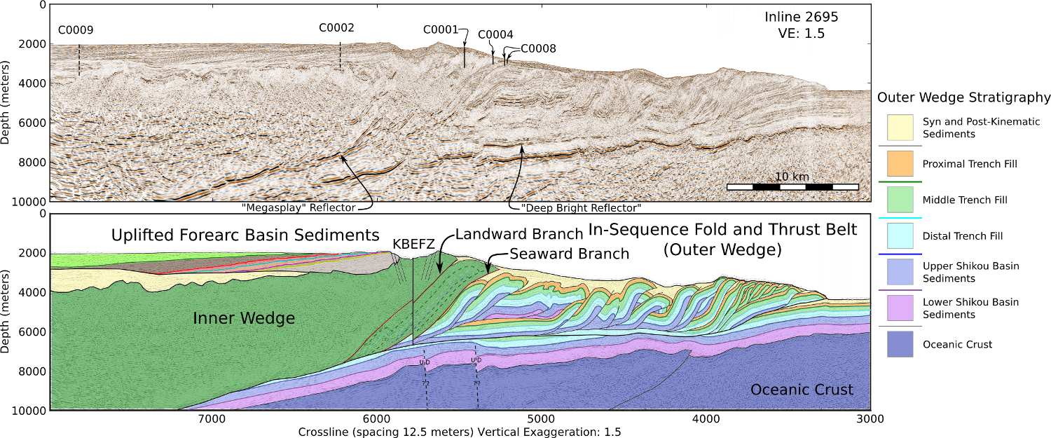
It is difficult to explain how geophysical data is processed and interpreted. This is because geophysics is actually advanced physics integrated with geology. For example; starting from the original wave, complex mathematical models, such as synthetic seismic profiles are used to get a somewhat clear image, called processed data, of what lies in the subsurface. The interpretation of these processed data requires years of education and experience. This article is targeted towards general public interested in science. Therefore, I will not go into significant detail on how this is done. You can see what a processed seismic data array and its interpretation looks like on the following image. Doesn’t it looks like an MRI or a sonogram of the Earth?
Geophysics and engineers work closely with geologists when making interpretations. It is a team effort that requires multiple skills. It is also possible for ten different teams of scientists interpreting the exact same data to produce ten different interpretations. Unfortunately only one of them is right or close to being right. There are hundreds of companies that have lost millions of dollars over the last 50 years or so and even to this day due to incorrect interpretations. This is why oil companies pay their employees well.
Footnotes:
Image credit: Seismic truck – Ryan Link, Geoscientist in Training, University of Calgary
Image credit: Charge containers – http://www.aryum.com/urunler-ve-uygulama-alanlari/patlayicilar/sivil-amacli-patlayicilar/sismik-patlayicilar
Image credit: Seismic line – https://github.com/joferkington/scipy2014-3d_seismic/blob/master/README.md
Proofread by: Nicholas Coffey, Chief Scientist, Coffey Geoscience, Salem OR