Warning!
All log images are copyrighted and have been reproduced on this site with permission. The original copyright holder is not, Sanuja Senanayake.Petrophysical (Well) Log Interpretation or Petrophysics Log Interpretation is a specialized area of science that deals with borehole data. In Canada, it is typically taught with physical core log interpretation and other geological and engineering fundamental concepts in most universities. Technical educational institutions and professional organizations offer courses in well log interpretation as a stand along subject. You can learn in depth at CRAIN’S PETROPHYSICAL HANDBOOK (www.spec2000.net). This page is best viewed on desktop computers due to small font size in well logs.
Disclaimer: While every reasonable effort is made to ensure that the information provided is accurate, no guarantees for the currency or accuracy of information are made. It takes several proof readings and rewrites to bring the quiz to an exceptional level. If you find an error, please contact me as soon as possible. Please indicate the question ID-Number or description because server may randomize the questions and answers.
Petrophysical Log Interpretation
Congratulations - you have completed Petrophysical Log Interpretation.
You scored %%SCORE%% out of %%TOTAL%%. With incorrect multiple attempts your score is %%PERCENTAGE%%
Your performance has been rated as %%RATING%%
Question 1 |
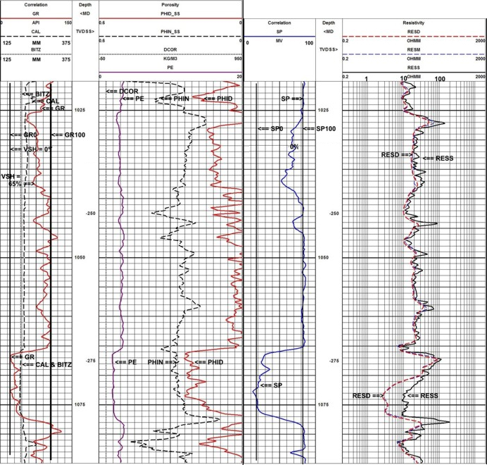
Image credit: Crain's Petrophysical Handbook, online at https://www.spec2000.net
Original at: https://www.spec2000.net/01-crainsrules.htm
A | At 1027 m |
B | At 1079 m |
C | At 1023 m |
D | At 1067 m |
E | At 1046.5 m |
Question 2 |
A | Braided channel |
B | Super-fan depositional lobes |
C | Channel-point bar |
D | Trangessive marine shelf |
E | Slope channel |
F | Prograding delta |
Question 3 |
Image credit: Crain's Petrophysical Handbook, online at https://www.spec2000.net
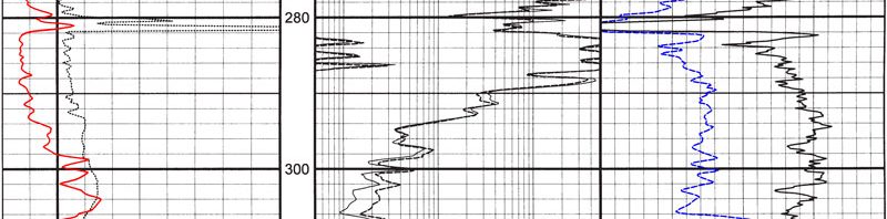
A | Between ~1070 m and ~1078 m |
B | Between ~1042 m and ~1043 m |
C | Between ~1066 m and ~1071 m |
D | Between ~1025 m and ~1028 m |
E | Between ~1066 m and ~1078 m |
Question 4 |
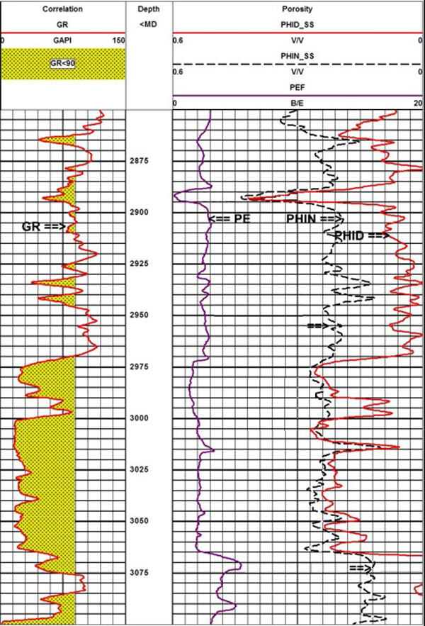
Image credit: Crain's Petrophysical Handbook, online at https://www.spec2000.net
Original at: https://www.spec2000.net/13-lithvisual.htm
A | Limy dolomite |
B | Shale |
C | Shaly sandstone |
D | Quartz arenite |
E | Dolomitic pelmicrite |
Question 5 |
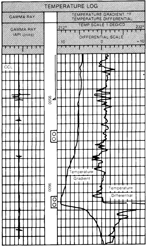
Image credit: Crain's Petrophysical Handbook, online at https://www.spec2000.net
Original at: https://www.spec2000.net/30-tmprlog.htm
A | Between 9550 ft to 9650 ft. |
B | From KB down to 9500 ft. |
C | Between 9500 ft and 9600 ft. |
D | From KB down to 9600 ft. |
Question 6 |
Image credit: Crain's Petrophysical Handbook, online at https://www.spec2000.net
Original at: https://www.spec2000.net/01-crainsrules.htm
A | Between 1071 m and 1078 m |
B | Between 1066 m and 1078 m |
C | Between 1047 m and 1060 m |
D | Between 1066 m and 1071 m |
E | Between 1049 m and 1055 m |
Question 7 |
Image credit: Crain's Petrophysical Handbook, online at https://www.spec2000.net
Original at: https://www.spec2000.net/30-tmprlog.htm
A | 9600 ft |
B | 9640 ft |
C | 9500 ft |
D | 958 0ft |
E | 9540 ft |
Question 8 |
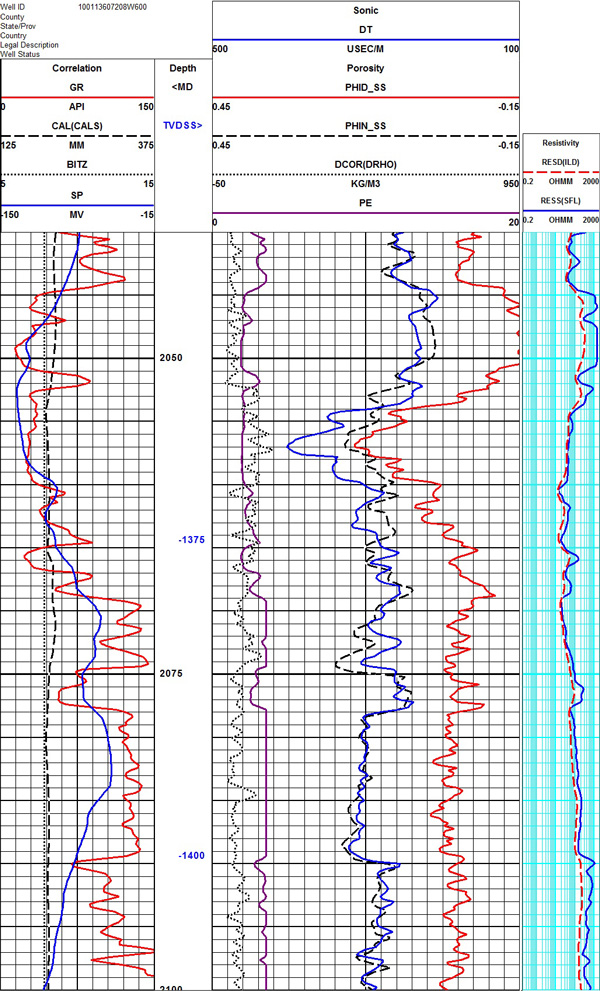
Image credit: Crain's Petrophysical Handbook, online at https://www.spec2000.net
A | 2047 m (+/- 5m) |
B | 2090 m (+/- 5m) |
C | 2057 m (+/- 5m) |
D | 2077 m (+/- 5m) |
E | 2047 m (+/- 5m) |
Question 9 |
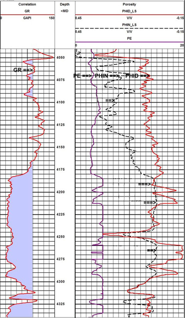
Image credit: Crain's Petrophysical Handbook, online at https://www.spec2000.net
Original at: https://www.spec2000.net/13-lithvisual.htm
A | Gas-bearing sandstone |
B | Gas-bearing dolomite |
C | Feldspatic (K-spar rich) arenite |
D | Shale interbeded sandstone |
E | Shaly sandstone |
F | Gas-bearing calcite |
Question 10 |
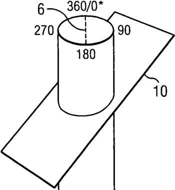
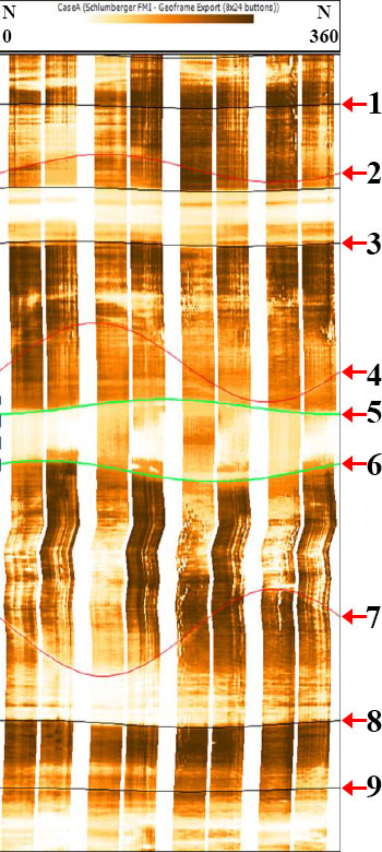
Original at: schematic diagram; http://www.google.com/patents/US20110064277
image log; Borehole image log analysis for sedimentary environment and clay volume interpretation by A. Shahinpour (NTUN) 2013
A | Fracture 8 and 9 |
B | Fracture 4 and 5 |
C | Fracture 4 |
D | Fracture 7 |
E | Fracture 1 and 2 |
Question 11 |
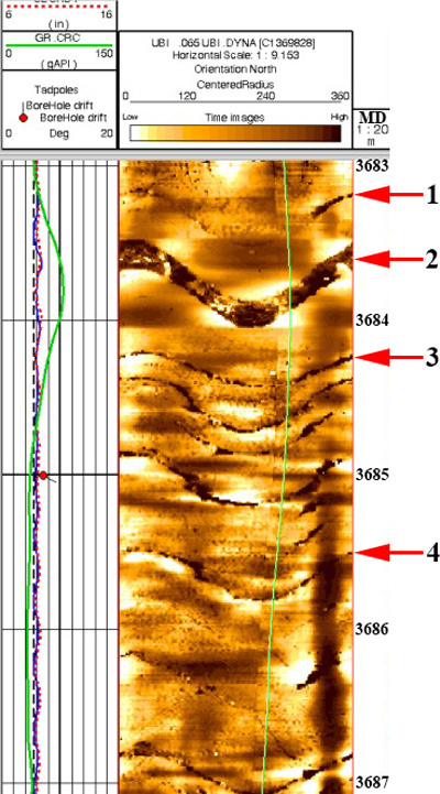
Image credit: Crain's Petrophysical Handbook, online at https://www.spec2000.net
Original at: https://www.spec2000.net/22-fracloc5.htm
A | Bedding contacts |
B | Effective porosity |
C | Lithological contacts |
D | Coal seams |
E | Fractures |
F | Hydrocarbon saturated zones |
Question 12 |
Image credit: Crain's Petrophysical Handbook, online at https://www.spec2000.net
Original at: https://www.spec2000.net/13-lithvisual.htm
A | Limestone |
B | Dolomite |
C | Anhydrite |
D | Argillaceous limestone |
E | Calcite |
F | Shale |
Question 13 |
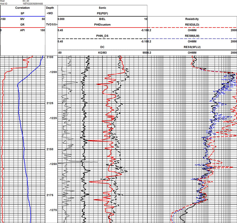
A | At around 2158 m of depth |
B | At around 2180 m of depth |
C | At around 2145m of depth |
D | At around 2102 m of depth |
E | At around 2110 m of depth |
Question 14 |
A | Low density shale |
B | Coal |
C | Organic rich black shale |
D | Shaly sandstone |
E | Heavy metals |
Question 15 |
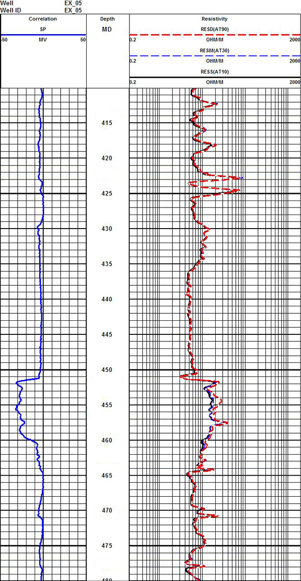
Image credit: Crain's Petrophysical Handbook, online at https://www.spec2000.net
Original at: https://www.spec2000.net/07-eslog.htm
A | At around 414 m , 422 m , 464 m , 470 m and 477 m |
B | At around 414 m , 451 m , 457 m , 464 m and 475 m |
C | At around 416 m , 451 m , 464 m , 470 m and 475 m |
D | At around 412 m , 414 m , 422 m , 470 m and 475 m |
E | At around 416 m , 451 m , 457 m , 470 m and 475 m |
Question 16 |
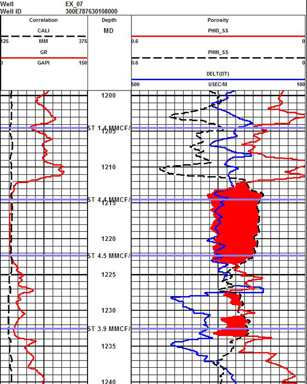
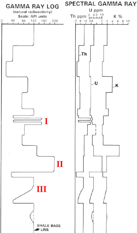
Image credit: Crain's Petrophysical Handbook, online at https://www.spec2000.net
Original at: https://www.spec2000.net/18-shalegas.htm
A | Between 1203 m to 1239.5 m |
B | Between 1209.5 m to 1211.5 m |
C | Between 1211.5 m to 1239.5 m |
D | Between 1212.5 m to 1223.5 m |
Question 17 |
Image credit: Crain's Petrophysical Handbook, online at https://www.spec2000.net
Original at: https://www.spec2000.net/07-eslog.htm
A | AT30 (dashed blue line) |
B | AT10 (black line) |
C | AT90 (dashed red line) |
D | It is difficult to determine with the given log. |
Question 18 |
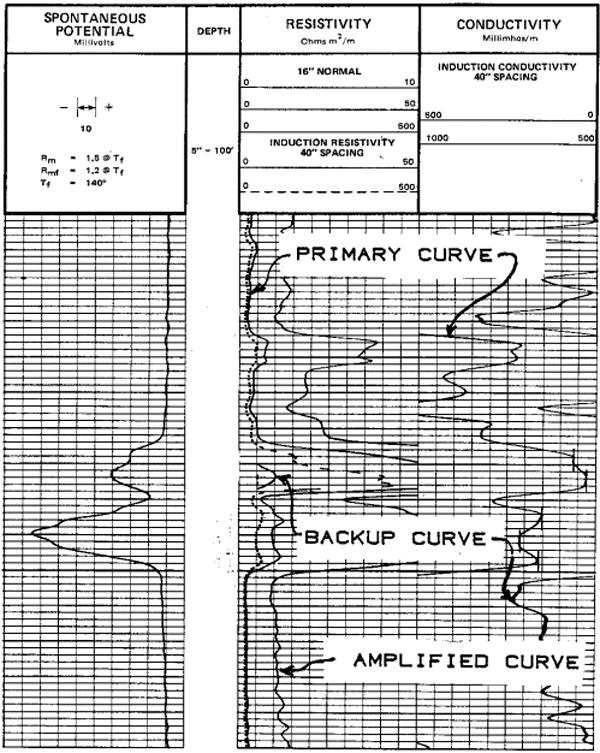
Image credit: Crain's Petrophysical Handbook, online at https://www.spec2000.net
Original at: https://www.spec2000.net/01-whatisalog.htm
A | Coal bearing formation |
B | High concentration of gas ("gas effect") |
C | High porosity formation |
D | Sandstone formation |
E | Presence of hydrocarbons |
Question 19 |
Image credit: Crain's Petrophysical Handbook, online at https://www.spec2000.net
A | Between ~1066 m and ~1071 m |
B | Between ~1070 m and ~1078 m |
C | Between ~1025 m and ~1028 m |
D | Between ~1042 m and ~1043 m |
E | Between ~1066 m and ~1078 m |
Question 20 |
Image credit: Crain's Petrophysical Handbook, online at https://www.spec2000.net
Original at: https://www.spec2000.net/13-lithvisual.htm
A | ~0.38 |
B | ~0.013 |
C | ~1.0 |
D | 0.0 |
E | ~75 |
Net sand interval = 3075 m - 3000 m = 75 m (read off the GR curve)
Hence, net:gross = 75 m/75 m = 1.0
Question 21 |
Image credit: Crain's Petrophysical Handbook, online at https://www.spec2000.net
A | Caprock |
B | Mudstone |
C | Seal |
D | Sandtone |
E | Shale |
Question 22 |
Image credit: Crain's Petrophysical Handbook, online at https://www.spec2000.net
Original at: https://www.spec2000.net/01-crainsrules.htm
A | Dolomite |
B | Clean sand |
C | Carbonaceous sandstone |
D | Dolomite with clay interbeds |
E | Limestone with sand interbeds |
Question 23 |
Image credit: Crain's Petrophysical Handbook, online at https://www.spec2000.net
Original at: https://www.spec2000.net/18-shalegas.htm
A | Oil saturated zone |
B | Water invaded zone |
C | Gas saturated zone |
D | Water saturated zone |
E | Coal seam regions |
Question 24 |
Image credit: Crain's Petrophysical Handbook, online at https://www.spec2000.net
Original at: https://www.spec2000.net/13-lithvisual.htm
A | Between 2945 m and 2970 m |
B | Between 2890 m and 2895 m |
C | At 3075 m |
D | Between 2970 m and 3075 m |
E | Between 3075 m and 3085 m |
Question 25 |
A | Just above position I |
B | Just above position II |
C | Just below position II |
D | At position I |
E | At position III |
Question 26 |
A | Shale |
B | Sandstone |
C | Interbedded clean sandstone and shale |
D | Coal |
E | Clean limestone |
Question 27 |
Original at: image log; Borehole image log analysis for sedimentary environment and clay volume interpretation by A. Shahinpour (NTUN) 2013
A | Fracture 4, 6 and 7 |
B | Fracture 3, 8 and 9 |
C | It is impossible to determine. |
D | Fracture 5 and 6 |
E | Fracture 4 and 5 |
Question 28 |
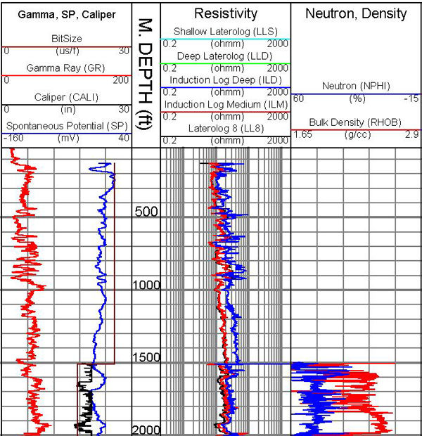
Image credit: United States Geological Survey, online at USGS database
A | Borehole collapse |
B | Intentionally changed the drill bit |
C | Drilling mud infiltration |
D | Soft lithological facies |
E | High pressure due to increased in depth |
Question 29 |
A | Heavy metals |
B | Glauconitic sandstone |
C | Gas bearing sandstone |
D | Organic rich black shale |
E | Interbeds of clean sand with shale |
Question 30 |
Image credit: Crain's Petrophysical Handbook, online at https://www.spec2000.net
A | Poor tool pads in the well |
B | Signal interference or poor tool calibration |
C | Inaccuracies in measurements due to mud infiltration |
D | Borehole collapse |
E | Tight oil |
Question 31 |
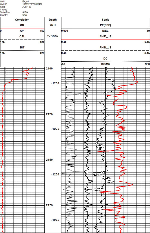
Image credit: Crain's Petrophysical Handbook, online at https://www.spec2000.net
A | Anhydrite |
B | Sandstone |
C | Glauconitic Sandstone |
D | Dolomite |
E | Limestone |
Question 32 |
Image credit: Crain's Petrophysical Handbook, online at https://www.spec2000.net
Original at: https://www.spec2000.net/13-lithvisual.htm
A | At 3095 m |
B | At 2955 m |
C | At 2995 m |
D | At 3011 m |
E | At 2893 m |
Question 33 |
A | At around 2177 m of depth |
B | At around 2102 m of depth |
C | At around 2158 m of depth |
D | At around 2105 m of depth |
E | At around 2110 m of depth |
Question 34 |
Image credit: Crain's Petrophysical Handbook, online at https://www.spec2000.net
Original at: https://www.spec2000.net/13-lithvisual.htm
A | Channel point bar deposit |
B | Interbeds of coal and sand |
C | Transgressive marine shelf |
D | Prograding marine shelf |
E | Slope channel deposit |
Question 35 |
Image credit: Crain's Petrophysical Handbook, online at https://www.spec2000.net
Original at: https://www.spec2000.net/13-lithvisual.htm
A | Anhydrite |
B | Calcite |
C | Dolomite |
D | Argillaceous dolomite |
E | Shale |
F | Argillaceous limestone |
Question 36 |
Image credit: Crain's Petrophysical Handbook, online at https://www.spec2000.net
Original at: https://www.spec2000.net/07-eslog.htm
A | Around 470 m of depth |
B | Around 422 m of depth |
C | Around 465 m of depth |
D | Around 460 m of depth |
E | Around 451 m of depth |
Question 37 |
A | Low density bitumen |
B | Fresh water |
C | Brine water |
D | Oil (petroleum) |
E | Natural gas |
Question 38 |
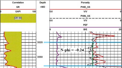
Image credit: Crain's Petrophysical Handbook, online at https://www.spec2000.net
Original at: https://www.spec2000.net/13-lithvisual.htm
A | ~ 0.18 |
B | ~ 0.48 |
C | ~ 0.27 |
D | ~ 0.36 |
E | ~ 0.24 |
Question 39 |
Image credit: Crain's Petrophysical Handbook, online at https://www.spec2000.net
Original at: https://www.spec2000.net/22-fracloc5.htm
A | 150 degrees Northwest |
B | 30 degrees Northwest |
C | 40 degrees Southeast |
D | 60 degrees Southeast |
E | 50 degrees Southeast |
Question 40 |
Image credit: Crain's Petrophysical Handbook, online at https://www.spec2000.net
A | Sandstone |
B | Dolomite |
C | Limestone |
D | Anhydrite |
E | Shale |
← |
List |
→ |
| 1 | 2 | 3 | 4 | 5 |
| 6 | 7 | 8 | 9 | 10 |
| 11 | 12 | 13 | 14 | 15 |
| 16 | 17 | 18 | 19 | 20 |
| 21 | 22 | 23 | 24 | 25 |
| 26 | 27 | 28 | 29 | 30 |
| 31 | 32 | 33 | 34 | 35 |
| 36 | 37 | 38 | 39 | 40 |
| End |
Credits: Based on the excellent class notes provided by, Dr. Rudi Meyer during Fall 2014 and the generous support from CRAIN’S PETROPHYSICAL HANDBOOK (spec2000.net) by supplying the petrophysical well log images. Some of the welllogs are produced by E.R. Crain, P.Eng. Those logs obtianed from E.R. Crain is the copyrighted intellectual property of the author.
FAQ | Report an Error
Supplementary Materials
Petrophysical Techniques; Geology/Geophysics (449)
Introduction to Petroleum Geology (577)
CRAIN’S PETROPHYSICAL HANDBOOK (www.spec2000.net)
If you are a company or an organization willing to donate copies of well logs, please contact me. I really appreciate your contributions and proper credits will be provided.