Notice
If you get a question wrong, you can still click on the other answers. This will open up hints and explanations (if available), which will provide additional information.Disclaimer: While every reasonable effort is made to ensure that the information provided is accurate, no guarantees for the currency or accuracy of information are made. It takes several proofreadings and rewrites to bring the quiz to an exceptional level. If you find an error, please contact me as soon as possible. Please indicate the question ID-Number or description because server may randomize the questions and answers.
Go to: Final
Geology (GLGY 341-UCAL) Midterm Exam
Congratulations - you have completed Geology (GLGY 341-UCAL) Midterm Exam.
You scored %%SCORE%% out of %%TOTAL%%.
Your performance has been rated as %%RATING%%
Credits: Based on the excellent class notes provided by, Dr. Bernard Guest during Winter 2013.
FAQ | Report an Error
Structural Geology Concepts
Strong skills in geometry, trigonometry, calculus, spatial visualization and sometimes structural engineering is very helpful in this field of study.
Use of Stereonet
Important!
To keep the loading time of this page to a minimum, the guidelines for using steronets has been moved here…(click here)Key terms:
Strike: azimuthal (bearing) relative to true north of a horizontal line on an inclined planar surface
Dip: angle of inclination of the surface of interest in the direction perpendicular to strike
Trend: of a line is the imaginary horizontal line of a vertical plane (similar to strike)
Plunge: angle of inclination in the vertical from the horizontal
Apparent dip: inclination from horizontal of any line on an inclined plane that is not perpendicular to strike
Pitch (rake): angle measured on an inclined plane, between the strike and any other line those lines in the plane. The line of greatest slope in any plane must have a pitch of 90-deg. The pitch of a line on a surface is measured by placing a protractor on the surface of the line
Basic Field Work
Strike and Dip
Best method: using brunton compass
Dumb method
Identifying Unstrain State
With the advancement in computerized databases on geotechnical data, today most companies use software programs to determine the original state of a geological feature. However, all of these programs are based on fundamental principles of structural geology and a geologist has to identify the features first before enter the data in to a computer system.
There are several ways to identify the original state of deposition, which include the following principles or laws:
- Principle (law) of Original Horizontality: due to the force of gravity acting on sediments, layers of sediments are always originally deposited horizontally.
- Principle (law) of Superposition: “Sedimentary layers are deposited in a time sequence, with the oldest on the bottom and the youngest on the top.”
- Principle (law) of cross cutting relationships: an igneous intrusion is always younger than the rock it cuts across.
If a structure do not follow these principles, it can be explained using geological events that effected the structure such as a fluid flow across a crack of a sediment after the sediment was deposited. This is used to compile a list chorological events in order to understand the nature of the sample.
Deformation
The deformation play a major role in how structures are form in nature. By definition, deformation is the transformation of a geological structure from an initial to a final geometrical shape by means of rigid body translation, rigid body rotation, strain and/or volume change. Understanding this definition is critical to further the knowledge in the field of structural geology.
Rotation is caused by the geologic structure rotated in a circle where center moves in a slower speed resulting in a short distance compared to the edges the speed is higher with greater distance.
Translation is caused by shifting the structure from an initial point to a final point. In translation, every single particle of a geologic unit or a structure moves in the same direction for same distance and at the same speed.
Strain and Stress are related to each other, but they are two different concepts. Stress is a force that is applied to a unit area where strain is the deformation of a geologic unit/structure as a result of strain. A geologist cannot observe stress, but rather deduce the characteristics of stress using the strain recorded in rocks and geologic structures. Strain can be classified in to three different categories; pure shear, simple shear, and subsimple shear..
– pure shear is caused by compressional forces into the geologic material from two sides.
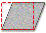
– simple shear occurs when a structure is subjected to stresses in opposite direction.
– subsimple shear is complicated because it is caused by a combination of simple shear and pure shear.
Please read more on this at: Shear Strain
Remember that deformation can only be identified using relative theory. In other words, deformation is the difference between known state of a structure to a final state of a structure. Most of the time geologists use known fossils to identify changes.
One dimensional strain involves only either stretching or shortening, where elongation, e is defined as:
e = (l-lo)/lo and l is the final length and lo is the initial length.
The stretching, s of a structure is defined as:
s = 1 + e OR s = l/lo
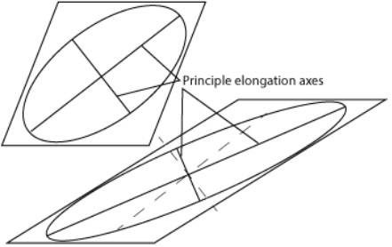
Two dimensional strains involves changes in structure in 2D on a plane, where angular shear, shear strain and strain ellipse is described using relative angles. This can be confusing since all angles are given relative to the normal of along a line; usually line A or line B. In angular shear, Ψ represents the angle between two originally perpendicular (the normal line of the undeformed original is perpendicular) lines.
Mohr Circle
Important!
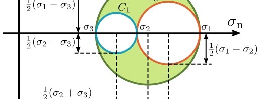
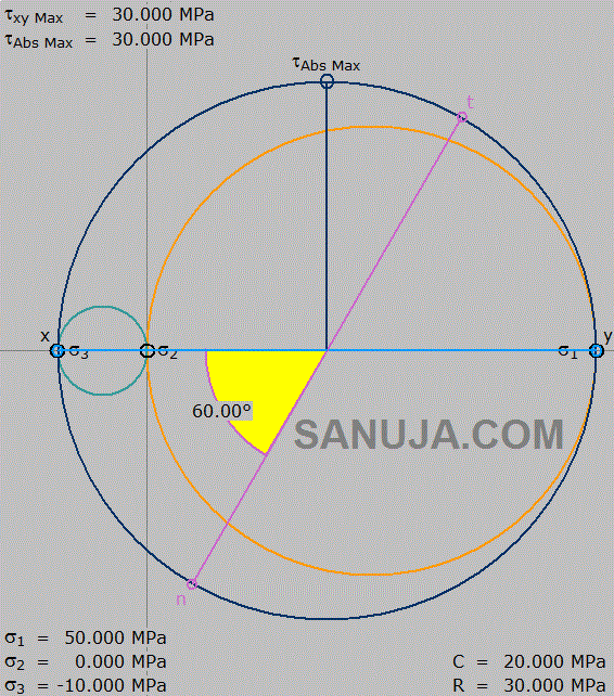
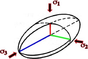
To keep the loading time of this page to a minimum, this information has been moved here…(click here)Mohr circle or Mohr diagram is named after Christian Otto Mohr is a 2D representation of a 3D stress on a structure on a point, often a crack.
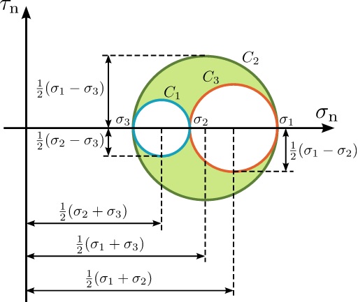
Triaxial Test
Triaxial test is a conventional testing method used in laboratory testing for obtaining shear strength parameters for different soil and rock types under a controlled stresses. The information obtained from such tests are used to determine the history of deformation events and the current strength conditions. The current strength conditions are used for constructing dams, building, roads and such. Not only the Geologists but also Engineers use information obtained from triaxial test.
Here are some videos of real life triaxial tests;
