Notice
If you get a question wrong, you can still click on the other answers. This will open up hints and explanations (if available), which will provide additional information.Disclaimer: While every reasonable effort is made to ensure that the information provided is accurate, no guarantees for the currency or accuracy of information are made. It takes several proof readings and rewrites to bring the quiz to an exceptional level. If you find an error, please contact me as soon as possible. Please indicate the question ID-Number or description because server may randomize the questions and answers.
Go to: Midterm Exam
Geology (GLGY 201-UCAL) Final Exam
Congratulations - you have completed Geology (GLGY 201-UCAL) Final Exam.
You scored %%SCORE%% out of %%TOTAL%%. With incorrect multiple attempts your score is %%PERCENTAGE%%
Your performance has been rated as %%RATING%%
Question 1 |
A | It measures the elevation change over the distance of flow. |
B | It measures the largest clast/sediment size a stream/river can transport. |
C | It measures the rate at which the transport system deposit its load over a distance. |
D | It measures the speed at which the river flows. |
E | It measures the change in capacity of sediment load over a distance. |
Question 2 |
A | headward erosion. |
B | drainage erosion. |
C | surface erosion. |
D | fracture network. |
E | dendritic network. |
Question 3 |
A | Mid-oceanic ridge environments |
B | Collisional orogenesis environments |
C | Extensional rifting environments |
D | Strike-slip environments |
Question 4 |
A | raising of the groundwater table at the global scale. |
B | increased availability of groundwater in shallow wells. |
C | lowering of the groundwater table at the regional scale. |
D | raising of the groundwater table at the regional scale. |
E | lowering of the groundwater table at the global scale. |
Question 5 |
A | 10 times less |
B | 1 times more |
C | 100 times less |
D | 10 times more |
E | 1 times less |
F | 100 times more |
Question 6 |
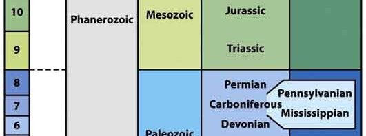
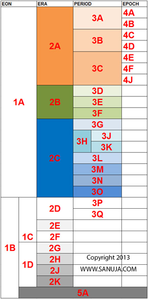
What is 3G on the following diagram? (ID-GLF-39)
Note: DO NOT scroll down to the Geologic Time scale on this page. Answer this question without using any AIDS.
A | Permian |
B | Cretaceous |
C | Cenozoic |
D | Devonian |
E | Eocene |
F | Jurassic |
Question 7 |
A | Normal fault |
B | Reverse fault |
C | Right-lateral strike slip fault |
D | Thrust fault |
E | Left-lateral strike slip fault |
Question 8 |
A | About 10 km |
B | About 100 km |
C | About 30 km |
D | About 5 km |
E | About 1 km |
Question 9 |
A | Mercalli discontinuity |
B | Wegener discontinuity |
C | Wadati-Benioff discontinuity |
D | Mohorovic discontinuity |
Question 10 |
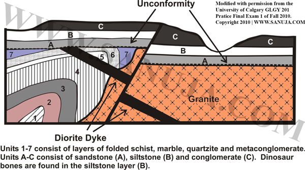
I. Deposition and folding of units 1 to 7
II. Intrusion of the granite pluton
III. Deposition of units A to C
IV. Formation of the unconformity
V. Faulting
VI. Intrusion of the gabbro dyke
A | VI (oldest) , I , III , V , II , IV (youngest) |
B | I (oldest) , III , VI , IV , II , V (youngest) |
C | V (oldest) , III , VI , IV , II , I (youngest) |
D | I (oldest) , II , VI , IV , III , V (youngest) |
E | VI (oldest) , II , III , IV , I , V (youngest) |
F | V (oldest) , II , VI , IV , III , I (youngest) |
Question 11 |
A | evaporation. |
B | infiltration. |
C | sublimation. |
D | transpiration. |
E | precipitation. |
Question 12 |
A | Study of the origins of rocks and minerals. |
B | Process of mountain building. |
C | Process of magma generation and solidification. |
D | Process of biological and geological evolution of life and Earth. |
E | Study of the origin of Earth and its evolution. |
Question 13 |
A | Ionosphere |
B | Thermosphere |
C | Exosphere |
D | Mesosphere |
E | Troposphere |
F | Stratosphere |
Question 14 |
A | Theory of Plate Tectonics |
B | Principle of Original Horizontality |
C | Principle of Uniformitarianism |
D | Principle of Superposition |
E | Theory of Geologic Evolution |
Question 15 |
A | hierarchical diagram |
B | historical tree |
C | phylogenetic tree |
D | taxonomy diagram |
E | ancestral diagram |
Question 16 |
A | Headward erosion |
B | Downcutting |
C | Subsidence |
D | Uplift |
E | Smaller lobes |
Question 17 |
A | A supercontinent that consisted of today’s South America, Africa, Antarctica, India, and Australia. |
B | The ocean that was once covered the Alberta region, which helped the formation of oil/gas deposits. |
C | A proposed Precambrian supercontinent that existed
around 1 billion years ago. |
D | A continent in the early Paleozoic Era composed of today’s North America and Greenland. |
E | The creatonic platform that forms the modern day Canada, USA and Mexico. |
Question 18 |
A | Between Mesosphere and Thermosphere. |
B | Around the 10 km altitude. |
C | Between Mesosphere and Troposphere. |
D | Between Mesosphere and Stratosphere. |
E | Around the 45 km altitude. |
Question 19 |
A | Within sedimentary rocks |
B | Within underwater mudslides |
C | Within fluvial deposits |
D | Withing igneous rocks |
E | Within metamorphic rocks |
Question 20 |
A | Overturned syncline |
B | Symmetric anticline |
C | Asymmetric syncline |
D | Symmetric syncline |
E | Asymmetric anticline |
Question 21 |
A | change its orientation |
B | retains the primary igneous structures. |
C | change its location |
D | change its shape by shortening |
E | most likely maintain the original mineral composition |
Question 22 |
A | shear |
B | stress |
C | strain |
D | deformation |
Question 23 |
A | Earth's crust |
B | Earth's mantle |
C | Heat absorbed by surface rocks |
D | Radioactive decay within the Earth's core |
E | Friction heat produced at plate margins |
Question 24 |
A | Sedimentary rocks due to regional heating. |
B | Metamorphic rocks due to contact metamorphism. |
C | Sedimentary rocks due to regional subduction. |
D | Igneous rocks due to uplift. |
Question 25 |
A | exosphere |
B | stratosphere |
C | thermosphere |
D | mesosphere |
E | troposphere |
F | ionosphere |
Question 26 |
A | It measure the flow rate of sediments at a fixed given location. |
B | It measures the rate of sediment supply to a stream/river system. |
C | It measures the volume of sediments transported by a stream/river system. |
D | It measures the largest clast/sediment size a stream/river can transport. |
E | It measures the rate at which the transport system deposit its load. |
Question 27 |
A | Slower than S-waves but faster than Love waves. |
B | Material moves back and forth parallel to the wave direction. |
C | Causes ground to ripple up and down like water waves in a lake. |
D | They are S-waves that intersects the land surface. |
E | They are P-waves that intersects the land surface. |
Question 28 |
A | shale and gabbro |
B | basalt and gabbro |
C | basalt and shale |
D | shale and limestone |
Question 29 |
A | Early Proterozoic |
B | Early Cenozoic |
C | Late Cenozoic |
D | Late Mesozoic |
E | Early Cambrian |
Question 30 |
A | reversing of the flow direction due to change in the direction of slope due to tectonic of other events. |
B | water levels are not high enough to maintain the flow resulting in change in stream direction. |
C | headward erosion by one stream causes the stream to intersect another stream. |
D | water levels and flow rates are too high for a river bed to maintain its shape result in collapse of valleys or canyons. |
Question 31 |
A | partial crystallization |
B | decompression crystallization |
C | fractional melting |
D | fractional crystallization |
Question 32 |
A | About 10 to 15 km |
B | About 0 to 5 km |
C | About 50 to 70 km |
D | About 30 to 40 km |
E | About 90 to 100 km |
Question 33 |
A | braided plane. |
B | alluvium fan. |
C | alluvium. |
D | stream terraces. |
E | graded deposits. |
Question 34 |
A | I. also known as vadose zones II. also known as zones of saturation |
B | I. sediment or rock structures that has very low permeability II. sediment or rock structures that has very high permeability |
C | I. subsurface regions where water accumulates II. subsurface structures that allow free flow of water |
D | I. geologic materials that act as a barrier to flow II. geologic materials that act as a barrier to flow |
E | I. geologic materials that transmit water II. geologic materials that act as a barrier to flow |
F | I. subsurface structures that allow free flow of water II. subsurface regions where water accumulates |
Question 35 |
A | surtseyan |
B | strombolian |
C | vulcanian |
D | phreatic |
E | plinean |
Question 36 |
A | Joints only occur in softer materials such as sediments and faults occur in hard rocks. |
B | Joints are fractures that have no offsets, while faults are fractures with offsets. |
C | Joints are much smaller in scale than faults. |
D | Joints are usually associated with igneous processes and faults are usually associated with orogenic processes. |
E | Joints are planar metamorphic fabrics while faults are planer surfaces of physical separations within rocks. |
Question 37 |
A | Factor of 2 |
B | Factor of 3 |
C | Factor of 10,000 |
D | Factor of 1 |
E | Factor of 20,000 |
Question 38 |
A | Permeability refers to the fraction of open space within rocks. |
B | Kerogen forms at the Earth's surface. |
C | Highly permeable rocks make very good petroleum seals/traps. Hint: Seal or trap rock/layers must be non-permeable to prevent hydrocarbons from escaping. |
D | Increasing depth often increase in hydrocarbon production. Hint: Yes, when you are within an oil/gas windows. But just because you increase in depth, doesn't mean it will favor formation of oil/gas. |
E | Oil window is smaller that that of natural gas window. |
Question 39 |
A | slip point |
B | epicenter |
C | trigger point |
D | focus |
Question 40 |
A | Mantle is ductile |
B | Increase in frictional forces |
C | Lower temperatures |
D | Increase in pressure |
E | Lack of water |
Question 41 |
A | P-wave |
B | Body wave |
C | Shock wave |
D | S-wave |
E | Surface wave |
Question 42 |
What is 3H on the following diagram? (ID-GLF-30)
Note: DO NOT scroll down to the Geologic Time scale on this page. Answer this question without using any AIDS.
A | Carboniferous |
B | Cretaceous |
C | Devonian |
D | Jurassic |
E | Permian |
F | Pennsylvanian |
Question 43 |
A | It occurs when the last member of a given family dies without producing any offspring. |
B | It occurs when the last member of a given class dies without producing any offspring. |
C | It occurs when the last member of a given genus dies without producing any offspring. |
D | It occurs when the last member of a given kingdom dies without producing any offspring. |
E | It occurs when the last member of a given species dies without producing any offspring. |
Question 44 |
A | Change in stress fields during metamorphism creating a differential stress which result in lineation of minerals. |
B | Collision of two or more air masses which result in formation of clouds, wind and rain. |
C | Change in pressure and temperature in magma underground which eventually leads to fractional crystallization. |
D | Movement of tectonic plates that result in formation of new crust due to upwelling of magma. |
E | Forces and events leading to a large structural deformation of the Earth's lithosphere resulting mountain building. |
Question 45 |
A | pressures. |
B | stress. |
C | lineation. Hint: This is true, but this is an observation and not a measurement. |
D | foliations. Hint: This is true, but this is an observation and not a measurement. |
E | strain. |
Question 46 |
A | 250 Ma |
B | 375 Ma |
C | 100 Ma |
D | 300 Ma |
E | 125 Ma |
Question 47 |
A | High clastic sediment deposits on the edge of the fan. |
B | Gradual decrease in grain size from corasest to finest as moving from the mouth to the distal edge. |
C | Muddy deposits closer to the mouth and sandy deposits distally at the edge. |
D | Very thick sandy deposits distally on the edge of the fan. |
Question 48 |
A | Bacteria |
B | Plantae |
C | Protista |
D | Fungi |
E | Animalia |
Question 49 |
Note: DO NOT scroll down to the Geologic Time scale on this page. Answer this question without using any AIDS.
A | Silurian |
B | Paleogene |
C | Cambrian |
D | Cretaceous |
E | Devonian |
Question 50 |
A | trench roll back |
B | ridge push |
C | slab pull |
D | suction force |
Question 51 |
A | Marginal faults |
B | Blind faults |
C | Inactive faults |
D | Crustal faults |
E | Active faults |
Question 52 |
A | 160 parent isotopes |
B | 40 parent isotopes |
C | 125 parent isotopes |
D | 250 parent isotopes |
E | 100 parent isotopes |
Question 53 |
A | Oxbow lakes are formed as a result of downcutting of the river into soft sediments hence they are unusually deep areas of a river. |
B | A meander that has been cut off yet remains filled with water forms an oxbow lake. |
C | Melting of glaciers at the surface (top) due to the heat from sun result in formation of oxbow lakes on top of the glacier itself. |
D | Melting of glaciers due to friction between the ground and itself forms oxbow lakes at the base of the glacier. |
E | All meandering rivers always from oxbow lakes. |
Question 54 |
A | Higher the friction between a glacier and the ground, faster the migration of the glacier. |
B | Higher the depth of a river, larger the volume of sediment deposition and accumulation on the river bed. |
C | Higher the mountains in collisional or convergent orogen, the deeper the crustal root. |
D | Plate tectonic movement is mostly driven by the energy obtained through the rotation of the Earth. Hint: This is what some scientists thought long time ago. This has been proven to be incorrect. |
E | Dykes are formed primarily due to preexisting weak planes of the country rock. |
Question 55 |
A | Strike-slip faults |
B | Reverse faults |
C | Normal faults |
D | Abnormal faults |
E | Thrust faults |
Question 56 |
A | Folds |
B | Faults |
C | Fractures |
D | Upside down beds (oldest on top) |
Question 57 |
What is 1A on the following diagram? (ID-GLF-24)
Note: DO NOT scroll down to the Geologic Time scale on this page. Answer this question without using any AIDS.
A | Phanerozoic |
B | Mesozoic |
C | Pennsylvanian |
D | Cenozoic |
E | Proterozoic |
Question 58 |
A | It occurs when sediments from deep underground which are formed under high pressure were exhumed in a short period of time. |
B | It occurs due to nuclear radiation caused by decomposition of radioactive elements within sediments and minerals. |
C | It occurs as the heat from magma melts the wall rock (country rock) resulting melting of the surrounding. |
D | It occurs when ground shake due to P-wave vibrates sediments hard enough resulting solids behaving like liquids. |
E | It occur when the pore water pressure increased enough to push sediment grains apart from each other. |
Question 59 |
A | Normal fault line |
B | Ridge or hill top |
C | Reverse fault line |
D | Valley or topographic depression |
Question 60 |
Please pay attention to the circled (green) area of the image.
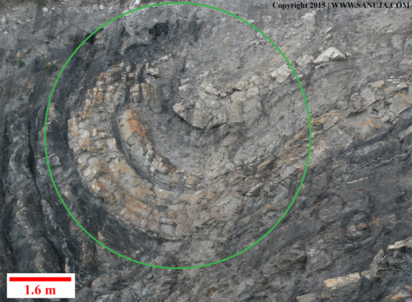
A | deformation caused by extensional tectonics. |
B | deformation that resulted in faulting. |
C | structural feature originated primarily due to an igneous event. |
D | deformation that resulted in folding. |
Question 61 |
A | temperature . heat |
B | climate , weather |
C | high pressure systems , low pressure systems |
D | precipitation . rain |
E | weather seasons , plate tectonics |
Question 62 |
A | They only occur in ductile regions. |
B | They are defined by the magnetic forces of the Earth. |
C | They are usually stationary and has been that for since the beginning of the Earth. |
D | They runs parallel to the equator of the Earth. |
E | They usually coincide with plate boundaries. |
Question 63 |
A | The focus is the location where a fault slips during an earthquake while epicenter is the point on the surface of the Earth directly above the focus of an earthquake. |
B | The epicenter is the location where a fault slips during an earthquake while focus is the point on the surface of the Earth directly above the focus of an earthquake. |
C | The focus is the geographic location of the seismometer and the epicenter is the physical position of the earthquake. |
D | They are interchangeable terms used geoscientists to describe earthquakes. |
E | The term focus is used when the earthquake occur under water/in oceans while the term epicenter is used when it occurs on land. |
Question 64 |
A | hot spots |
B | transform zones |
C | mid-ocean ridges |
D | subduction zones |
Question 65 |
A | The clumping together of clay suspended in river water into bunches that are large enough to settle out. |
B | The process by which atoms dissolved in a solution come together and form minerals. |
C | The fossilization process in which plant material becomes transformed into rock by the precipitation of silica from groundwater. |
D | The process by which a magma becomes progressively more silicic as it cools, because early formed crystals settle out. |
E | Formation of new minerals when preexisting minerals change into new minerals as a result of an increase in pressure and temperature. |
Question 66 |
A | Cooling or heating of air or matter without increasing or decreasing of pressure. |
B | Cooling or heating of air or matter without the addition or subtraction of thermal energy. |
C | Cooling or heating of air or matter without the addition or subtraction of atoms or molecules. |
D | Cooling or heating of air or matter through compression solidification or decompression melting. |
E | Cooling or heating of air or matter through geologic uplift. |
F | Cooling or heating of air or matter without decreasing or increasing of temperature. |
Question 67 |
What is 3L on the following diagram? (ID-GLF-20)
Note: DO NOT scroll down to the Geologic Time scale on this page. Answer this question without using any AIDS.
A | Devonian |
B | Triassic |
C | Jurassic |
D | Pennsylvanian |
E | Ordovician |
Question 68 |
A | asymmetrical anticline |
B | symmetrical anticline |
C | asymmetrical syncline |
D | symmetrical syncline |
Question 69 |
What is 2A on the following diagram? (ID-GLF-24)
Note: DO NOT scroll down to the Geologic Time scale on this page. Answer this question without using any AIDS.
A | Pennsylvanian |
B | Cenozoic |
C | Proterozoic |
D | Mesozoic |
E | Phanerozoic |
Question 70 |
A | Mesopause |
B | Orogeny |
C | Induced equilibrium |
D | Accretion |
E | Isostasy |
Question 71 |
A | An area that is damaged by a recent earthquake. |
B | An area where geoscientists predicted to have an earthquake in near future. |
C | An area that has been known to have earthquakes in high frequency in the past. |
D | The epicenter of an earthquake. |
E | None of the listed answers are correct. |
Question 72 |
A | mesosphere |
B | troposphere |
C | thermosphere |
D | stratosphere |
E | exosphere |
Question 73 |
A | Vesicles and voids within matrix |
B | Reef framework |
C | Inter granular porosity |
D | Dissolution |
Question 74 |
A | Ductile deformation |
B | Low pressure and high temperature |
C | Brittle deformation |
D | High pressure and low temperature |
E | At extensional settings |
Question 75 |
A | A supercontinent that consisted of today’s South America, Africa, Antarctica, India, and Australia. |
B | A proposed Precambrian supercontinent that existed
around 1 billion years ago. |
C | The ocean that was once covered the Alberta region, which helped the formation of oil/gas deposits. |
D | A continent in the early Paleozoic Era composed of today’s North America and Greenland. |
E | None of the answers are correct. |
Question 76 |
A | Higher rate of leaking groundwater into rivers and lakes due to higher formation pressures. |
B | Injection/addition of water into the ground due to heavy rainfall. |
C | Extraction of groundwater in large volumes in a small period of time. |
D | Extraction of groundwater in large volumes in a long period of time. |
Ref: Dr. Alexander Dutchak Fall 2015 lecture notes.
Question 77 |
A | Basin and Range |
B | Hawaiian Islands |
C | Himalayas |
D | Canadian Rockies |
Question 78 |
A | A supercontinent that consisted of today’s South America, Africa, Antarctica, India, and Australia. |
B | None of the answers are correct. |
C | A continent in the early Paleozoic Era composed of today’s North America and Greenland. |
D | The ocean that was once covered the Alberta region, which helped the formation of oil/gas deposits. |
E | A proposed Precambrian supercontinent that existed
around 1 billion years ago. |
Question 79 |
A | A group of fossils native to a specific region. |
B | A set of fossils that can be arranged in chronological order. |
C | None of the answers are correct. |
D | A set of fossils belongs to the same family of organisms. |
E | A group of fossil species found in a specific sequence of sedimentary rock. |
Question 80 |
A | I basins II. arcs |
B | I. synclines II. anticlines |
C | I. arcs II. basins |
D | I. anticlines II. synclines |
Question 81 |
A | carbon dioxide |
B | ammonia |
C | water vapor |
D | oxygen |
E | nitrogen |
Question 82 |
A | Resistance of its walls to erosion slumping. |
B | Its elevation from the sea level. |
C | Sediment load of the river/stream. |
D | Flow rate of the water (velocity) and the volume of water. |
Question 83 |
A | Sudden decrease in energy of a river system result in accumulation of the bedloard. |
B | Deposition of organic matter on terrestrial sediments due to decay of plants and organisms. |
C | Erosion of high standing sedimentary structures and subsequent deposition of the materials downstream. |
D | Accumulation of microscopic shells and file flakes of clay at the ocean floor. |
E | Deposits of rock fragments and sediments left behind after a glacier has migrated through a region. |
Question 84 |
A | Bottled gas |
B | Gasoline |
C | Heating oil |
D | Natural gas |
E | Kerosene |
F | Tar |
Question 85 |
A | Divergent lifting |
B | Frontal lifting |
C | Convergence lifting |
D | Orographic lifting |
E | Convective lifting |
Question 86 |
A | Sm/Nd |
B | Rb/Sr |
C | U/Pb |
D | K/Ar |
Question 87 |
A | Sodium |
B | Magnesium |
C | Calcium |
D | Potassium |
E | Chloride |
Question 88 |
-Deformation
-Faulting
-Folding
-Partial melting
-Foliation
-Metamorphism
-Glaciation
-Erosion
-Sedimentation
A | All of the above can be observed in mountain building processes. |
B | Partial melting and Sedimentation |
C | Glaciation and Sedimentation |
D | Partial melting |
E | Partial melting, Sedimentation and Glaciation |
Question 89 |
A | Conglomerate |
B | Siltstone |
C | Mudstone |
D | Sandstone |
Question 90 |
A | 4.54 Ga |
B | 4.03 Ga |
C | 3.87 Ga |
D | 3.55 Ga |
E | 3.92 Ga |
Question 91 |
A | Isostasy |
B | Orogeny |
C | Induced stability |
D | Equilibrium |
Question 92 |
A | The temperature below which crystals are first formed. |
B | The temperature above which crystals are first formed. |
C | The temperature above which the water is neither a gas nor a liquid. |
D | The temperature below which magma no longer have the ability to erupt out of the volcano. |
E | The temperature below which isotopes are no longer free to move. |
Question 93 |
A | nitrogen |
B | water |
C | methane |
D | carbon dioxide |
E | ammonia |
Question 94 |
A | 1000 - 1500 m |
B | 5 - 7km |
C | 40 - 50 km |
D | 15 - 20 km |
E | 500 - 1000 m |
Question 95 |
A | on overriding plate , landwards |
B | seawards , on the extinct arc |
C | None of the answers are correct. |
D | landwards , on overriding pate |
Question 96 |
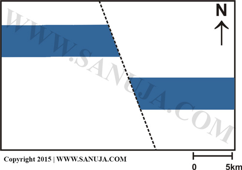
Note: Do not worry about the vector arrows. This animation was created for 300/500-level structure classes.
A | Not enough information is provided in the question. |
B | Reverse fault |
C | Right lateral strike-slip fault |
D | Normal fault |
E | Left lateral strike-slip fault |
Question 97 |
A | Unconfined aquifers with very high permeability. |
B | Aquifers with very low porosity and permeability. |
C | Confined aquifers with very high permeability. |
D | Aquifers with very high porosity, but very low permeability. |
Question 98 |
A | Wadati-Benioff scale |
B | Seismic-moment magnitude scale |
C | Mercalli scale |
D | Richter scale |
Question 99 |
A | Volcanic eruptions |
B | Magma migration |
C | Sudden changes in mineral structures |
D | Human interference such as construction and nuclear detonations |
E | Crustal fault slips |
Question 100 |
A | be refracted |
B | bent away from the normal |
C | split into several rays |
D | disintegrate |
E | bent towards the normal |
Question 101 |
A | Carbon and oxygen |
B | Carbon and nitrogen |
C | Carbon and hydrogen |
D | Carbon, nitrogen and oxygen |
E | Carbon, hydrogen and oxygen |
Question 102 |
A | None of the answers are correct. |
B | We measure stress using specialized equipment that keep track of movement of geologic masses. |
C | We measure stress based on detection of earthquakes and their magnitudes with respect to location. |
D | We measure stress using changes in pressure and temperature observed within geologic materials over a period. |
E | We cannot directly measure stress, but we can infer stress using strain preserved as deformations in minerals and rocks. |
Note: Most than one answer is correct. But on multiple choice exams, you should choose the MOST suitable answer. Consider this question as a good example for your future university exams.
Question 103 |
A | Monthly |
B | Yearly |
C | Weekly |
D | Daily |
Question 104 |
A | in rift valleys |
B | on the continental shelf |
C | in oceanic trenches |
D | on the abyssal plain |
Question 105 |
A | Soft substrate with high degree of erosion |
B | High sediment carrying capacity |
C | Very low stream gradient |
D | Narrow flood plains |
Question 106 |
A | The hydraulic head must be very high in the wetland regions. |
B | The permeability must be very low in the wetland regions. |
C | The vadose zone must be extremely large (deep) in the wetland regions. |
D | The water table must be relatively high in the wetland regions. |
Question 107 |
A | inclusions only occur in magma chambers. |
B | younger rocks are always will be on top of the older rocks. |
C | inclusions are always older than the rock which contains them. |
D | inclusions never appear on the surface of rocks. |
E | inclusions are younger than the rock which contains them. |
Question 108 |
Precambrian is divided into two Eons as shown on the following diagram as 1C and 1D. What are they? (ID-GLF-62)
Note: DO NOT scroll down to the Geologic Time scale on this page. Answer this question without using any AIDS.
A | Paleozoic and Mesozoic |
B | Phanerozoic and Proterozoic |
C | Paleozoic and Phanerozoic |
D | Proterozoic and Archean |
E | Cenozoic and Mesozoic |
Question 109 |
A | Interior waves |
B | Rayleigh waves |
C | Body waves |
D | Love waves |
Question 110 |
A | Seismic waves were first discovered by Andrija Mohorovicic. |
B | Surface seismic waves are the fastest in terms of travel time. |
C | Seismic waves that enters a faster medium from a slower medium will undergo refraction towards the normal. |
D | Seismic waves travel faster in high density mediums. |
E | Seismic waves are able to sustain their energy in softer mediums for a longer period of time. |
Question 111 |
A | P-waves disappeared at the mantle-outer core boundary |
B | S-waves disappeared at the mantle-outer core boundary |
C | R-waves disappeared at the mantle-outer core boundary |
D | L-waves disappeared at the mantle-outer core boundary |
Question 112 |
A | decrease in density of the medium. |
B | increase in density. |
C | increase in travel distance. |
D | increase in density of the medium. |
Note: Any changes in density of the medium affect both P and S waves.
Question 113 |
A | Appalachian orogeny occurred at the same time as the Grenville orogeny. |
B | Appalachian orogeny occurred after the Grenville orogeny. |
C | Appalachian orogeny is occurred as a result of four separate continental collisions. Hint: Three separate continental collisions. |
D | Allegheny Mountains formed before the both of the Appalachian and Grenville orogenies. |
Question 114 |
A | It is a bar where ice cold drinks are served only for cool geoscientists. |
B | It is a representation of pressure - temperature boundaries which specific minerals may form out of a magma. |
C | It is an imaginary line that separates the four major layers of atmosphere. |
D | It is a line on a map used to separate different air pressures. |
E | It is a graphical representation of change in temperature with depth in the lithosphere. |
Question 115 |
A | Principle of Superposition |
B | Theory of Rock Cycle |
C | Principle of Original Horizontality |
D | Principle of Uniformitarianism |
E | Theory of Geologic Evolution |
F | Theory of Plate Tectonics |
Question 116 |
A | There must be a very large cone of depression directly under the road surface in question causing surface to subside during warm and dry seasons. |
B | The groundwater must be flowing at a faster rate during wet spring and summer than during winter causing subsurface erosion. |
C | Weight of the materials used to construct the road surface is effecting the groundwater pressures in the subsurface. |
D | Pore pressures that holds the grains apart fluctuates causing subsidence during warm summers and uplift during wet winters and springs. |
Question 117 |
A | oil window. |
B | ideal temperature. |
C | ideal window. |
D | decomposition temperature. |
E | critical temperature. |
F | critical window. |
Question 118 |
A | Burrows |
B | Skeletons |
C | Amber embedded fossils |
D | Shell fragments |
E | Petrified wood |
Question 119 |
A | 5.5% |
B | 31.6% |
C | 5% |
D | 0.5% |
Question 120 |
A | Non-uniform boundary conditions between two moving sections. |
B | Friction between two moving sections. |
C | Compression pressure along the contact boundary between two moving sections. |
D | Mineral alignment along the contact points between two moving sections. |
E | Ductile nature of the two moving sections. |
← |
List |
→ |
| 1 | 2 | 3 | 4 | 5 |
| 6 | 7 | 8 | 9 | 10 |
| 11 | 12 | 13 | 14 | 15 |
| 16 | 17 | 18 | 19 | 20 |
| 21 | 22 | 23 | 24 | 25 |
| 26 | 27 | 28 | 29 | 30 |
| 31 | 32 | 33 | 34 | 35 |
| 36 | 37 | 38 | 39 | 40 |
| 41 | 42 | 43 | 44 | 45 |
| 46 | 47 | 48 | 49 | 50 |
| 51 | 52 | 53 | 54 | 55 |
| 56 | 57 | 58 | 59 | 60 |
| 61 | 62 | 63 | 64 | 65 |
| 66 | 67 | 68 | 69 | 70 |
| 71 | 72 | 73 | 74 | 75 |
| 76 | 77 | 78 | 79 | 80 |
| 81 | 82 | 83 | 84 | 85 |
| 86 | 87 | 88 | 89 | 90 |
| 91 | 92 | 93 | 94 | 95 |
| 96 | 97 | 98 | 99 | 100 |
| 101 | 102 | 103 | 104 | 105 |
| 106 | 107 | 108 | 109 | 110 |
| 111 | 112 | 113 | 114 | 115 |
| 116 | 117 | 118 | 119 | 120 |
| End |
Credits: Based on the excellent class notes provided by, Dr. Gerald Osborn during Fall 2010 and textbook ISBN-978-0-393-93750-3. This version has been updated on between September and December 2015 using excellent class notes provided by, Dr. Glenn Dolphin, Alex Dutchak and Dr. Brandon Karchewski during Fall 2015.
FAQ | Report an Error
Concepts and Additional Questions for Fall 2010 Final
Important!
↑ Some of these are already in the exam type questions in the quiz(above) ↑
Answers to these will NOT be posted. These are based on 2010 lecture notes!
-Know the definitions and features of Composite Volcanos (CV) and Shield volcanos (SV).
-Types of crystallization processes
-Geologic zones; subduction, mid ocean, etc and their features
-Difference between nonconformity and disconformity.
-Difference between stress and strain.
-Differences between tensile stress, compressional stress and shear stress
-Understanding geologic events based on relative deposition.
-Earthquakes and their nature of intensity.
-Types of waves; S-,P-,L- and R- waves.
-Earth’s components and their variation in composition.
-Be able to interpret features on a given map or cross-section.
-Mohorovic discontinuity and it’s importance to geologic studies.
-Know, asymmetrical syncline/anticline, symmetrical syncline/anticline.
-General history of geology as a study subject.
-Concept; slab pull, ridge push and hypothesis on why these occur.
-You should memorize this time scale. Yes, this will most likely appear on the final, but also very useful for the future of your geologic carrier. Most geologists and geophysicsts remember the Geologic Time Scale with respect to important events took place in the history.
