3D Geologic Structures and Methods
For more detailed set of questions, visit: Geology 341 – Structural Geology. Only specific questions related to 3D structures are posted on the following quiz. Please report all errors via Contact Form.
Updating…..
Geology (GLGY 343-UCAL) Final Exam
Congratulations - you have completed Geology (GLGY 343-UCAL) Final Exam.
You scored %%SCORE%% out of %%TOTAL%%.
Your performance has been rated as %%RATING%%
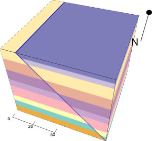
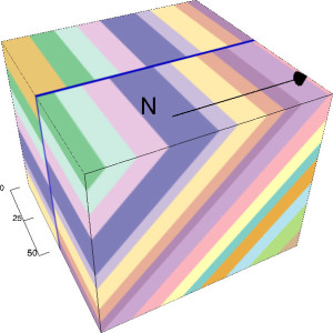
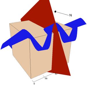
3D visual diagrams were created by: Visible Geology
Definitions
angular unconformity
Horizontally parallel strata of sedimentary rock are deposited on tilted and eroded layers, producing an angular discordance with the overlying horizontal layers. Bedding planes of the rocks above and below are not parallel.
anticline
A fold of rock layers with a convex shape pointing upwards with the oldest rock/formation in the middle.
apparent dip
A dip measurement made in any other direction that not perpendicular to the strike. Apparent dip is never larger than true dip.
attitude or orientation of a plane or line
???????????????????
axial plane
A line drawn in on a section through the position of the fold axis for each bed to show the surface at which the two limbs meet.
axial surface
Trace of geologic surface is the line of intersection of a geologic surface with topography
azimuth
The horizontal angle between a line and a coordinate direction(mostly True north) measured clockwise.
basemap
A basemap provides a user with context for a map. A typical basemap would provide the North direction and basic geographical features.
basement
The oldest rocks recognized in a given area, a complex of metamorphic and igneous rocks that underlies all the sedimentary formations. Usually Precambrian or Paleozoic in age.
bed
Layered structure from the deposition of sediments in sheets. Tabular/lenticular units of specific lithologic and textural characteristics, separated from adjacent beds by distinct bedding planes or bounding surfaces
benchmark
A well-defined, permanently fixed point in space, used as a reference from which measurements of any sort (such as of elevations) may be made. It is marked BM on the map and are useful to help determine contour lines.
clinoform
A sloping depositional surface
clinometer
A magnetic compass used to measure slope and elevation with respect to a spirit level.
coastal plain
A low plain of little relief adjacent to the ocean and covered with gently dipping sediments. Its strata either horizontal or very gently sloping toward the water, and that generally represents a strip of recently prograded or emerged sea floor.
conformable contact
Strata deposited on top of each other in layers with oldest at bottom and youngest at top with no significant time gap/break in deposition.
contour interval
The vertical distance between equally spaced horizontal planes intersecting with a surface at equal elevation.
datum
An artificially established, well surveyed horizontal plane against which elevations, depths, tides, etc. are measured (for example mean sea-level). It is an arbitrary horizontal reference line.
disconformity
Division between parallel rock strata, indicating interruption of sedimentation.
discordance
Lack of parallelism between adjacent strata.
fence diagram
Used for representing stratigraphic data in three dimensions. 3D diagram consisting of a 3D network drawn in two dimensions.
floodplain
Land area adjacent to a stream, composed of unconsolidated sedimentary deposits (alluvium) and subject to periodic flooding.
fold axis
A line which lies parallel to the hinge line and marks the intersection of the axial plane with the hinge zone.
formation
Consists of a certain number of rock strata that have a comparable lithology, facies or other similar properties
geological horizon or unit
either a bedding surface where there is marked change in the lithology within a sequence of sedimentary or volcanic rocks, or a distinctive layer or thin bed with a characteristic lithology or fossil content within a sequence.
geopetal structure
A sedimentary fabric which records the way up at the time of deposition.
heterolithic strata
Sedimentary structure made up of interbedded deposits of sand and mud.
orientation of a plane or line
See attitude or orientation of a plane or line. It is the basic unit of stratigraphy.
isopach map
Illustrates thickness variations within a tabular unit, layer or stratum (Isopachs are contour lines of equal thickness over an area).
magnetic declination
Angle between magnetic north (the direction the north end of a compass needle points) and true north.
nonconformity
an unconformity that separates crystalline rocks, either igneous or metamorphic, from sedimentary rocks.
paraconformity
is a type of disconformity in which the separation is a simple bedding plane with no obvious buried erosional surface.
principle of original horizontality
Layers of sediment are originally deposited horizontally under the action of gravity.
principle of superposition
Youngest layer is on top and the oldest on bottom.
progradation
Growth of a river delta farther out into the sea over time.
relief
Difference in elevation between any two points; local relief is the difference between adjacent points (e.g., a hill and a valley); total relief is the difference between the highest and lowest points on the map.
syndepositional
Process or an event that occured during deposition.